Around this time of year, specifically between Thanksgiving and New Years, some of us tend to go up a pant size or two. With so much good food, maybe a little too much eggnog (with brandy, of course), and weather cold enough to keep you inside for days at a time, it’s a wonder we all don’t start acting like Chris Farley when he sees french fries.
So as you start planning out your New Years resolutions, whether you’re traveling to see family, going on vacation, or staying at home, here are some of the best websites/apps I use to find running and hiking trails to help keep fit. Some of these can be especially useful when you’re in a new location and have no idea what’s around.
Finding Trails
AllTrails. Has an app? Yes. AllTrails has a huge database of over 50,000 trails across the US. You can explore trails by type such as trail running, hiking, and waterfalls, and you can also explore by location. You can create a free account to save your favorites, mark off which trails you’ve completed, etc. If you want to be able to download, print, or create custom maps, that requires an upgrade to AllTrails Pro for $29.99/year.
TrailLink. Has an app? Yes. TrailLink provides trails that are connected to the Rails-to-Trails conservancy effort, which include rail trails, canal trails, and greenways (non-rail trails). This is a major effort across the US, and converting old railroad tracks into trails is something that each state has become involved in. Plans to create the East Coast Greenway, for example, are being brought to life in part by the rails-to-trails effort. Much like AllTrails, there is a free version and a pro version for $29.99/year.
Oh, Ranger! Has an app? Yes. Oh, Ranger! is one of my go-to apps while traveling. Admittedly, this app is better used for finding parks, but you can narrow down parks by activities such as hiking. Just be aware that Oh, Ranger! will spit out every park in that area, no matter how big or small, so you may have to filter through some of them in order to find one worth going to. One helpful feature is that Fed/State parks are labeled as such, and often provide better hiking/running opportunities than local parks.
Trails.com. Has an app? No. One of the better trail sites on the web, it’s unfortunate there is no corresponding app. For trail finders, you can filter by National Park trails, State Park trails, popular city trails, trails in Canada, and more.
EveryTrail. Has an app? No. EveryTrail used to have an app, but it’s no longer available. EveryTrail is useful because it provides a worldwide database of trails and you can save your favorites. It also has themed local hikes. For example, in Austin there is a “Texas History Inside and Out” themed trail, which is 3.3 miles of walking to and from various historic buildings.
National Scenic Trails and National Historic Trails. Has an app? No. Located on the National Parks website, these trails literally take an act of Congress to be designated as a national scenic and/or historic trail. These trails are typically long distance that can take days, weeks, or even months to complete. However, that doesn’t mean you can’t go out and hike the Appalachian Trail for a few hours. These are often a source of hiking bucket lists and are truly major accomplishments.
National Recreation Trails. Has an app? No. Differing slightly from the National Scenic and Historic Trails, Congress does not need to designate a NRT. The Secretary of the Interior or Agriculture designate NRTs annually. You can search the online database, currently consisting of over 1200 trails across all 50 states, with trail distances ranging from less than 1 mile to 485 miles long.
MapMyRun or MapMyHike. Has an app? Yes. Both apps do basically the same thing, so use whichever one you prefer. The reason I’m including MapMyRun and MapMyHike on here is because if you upgrade to the MVP version for $29.99/year, it comes with a feature called Route Genius. With Route Genius, the app locates you and you enter how many miles you want to run, what direction you want to run (optional), and if you want to avoid highways. Route Genius will generate a route for you and if you don’t like the route, keep generating routes until you like one. For me, I like running/hiking circuit routes so I can look at new scenery the whole way, so I keep clicking until I get a circuit route. This feature comes in handy when you’re in a new place or you’re just looking for a new route.
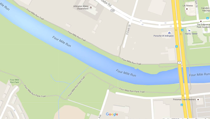
Google Maps. Has an app? Yes. When all else fails, open Google Maps. If you’re a map geek like me, and you like to study maps just for fun, it’s pretty easy to find trails. In the example below from Arlington, VA, you can see the Four Mile Run trail clearly labeled and you can even see trail offshoots, like the one leading to Eads/Glebe Rd.
Accountability
Now that you have all these options to choose from, it’d be great to track how many miles you run/hike and which trails you’ve already done.
Many of the sites above allow you to save trails and then mark them off as complete when finished, but for real-time tracking AllTrails allows you to record your hike.
However, my go-to app for tracking real-time stats no matter if it’s a run or a hike is MapMyRun. Another feature I like about MapMyRun is that any friends you connect to on the app can see when you’re working out, and they can also “like” and comment on your run after you’re done. This seemingly standard feature can actually be pretty motivating when you know that others can see your results and progress over time. And if any of those friends start to give you crap, you can challenge them to daily, weekly, or monthly competitions based on most steps, most workouts, most distance, most calories burned, or most workout time.
Other running apps to consider are the Nike+ app and Runkeeper.
One final app that I like for accountability purposes is the Passport to National Parks app. In addition to finding parks, you can keep track of parks visited.
Alright, now that you have enough trails to last you for the rest of your life, there’s no excuse for breaking this New Year’s resolution. And when you’re in a new city, WALK! It’s the best way to see a city and many cities will offer free guided walking tours if you’re unsure of where to go. Just Google “city name” + walking tour and see if anything comes up.
What other websites or apps do you use for running and hiking? Any good international databases?


Leave a Reply